Where does our drinking water come from?
December 13, 2010 Leave a comment
 The City of Mercer Island operates the water distribution system on the island. But where does the water come from that is delivered to MI homes, schools and businesses?
The answer is it comes to us by pipe across the lake. Our water is supplied to us by Seattle Public Utilities. SPU operates a collection and treatment system that delivers clean drinking water to Seattle, Mercer Island, Bellevue, Kirkland, Bothell and other communities in the region. It serves a total of almost 1.4 million people.
A report published by SPU tells an interesting story.
“While population has steadily risen since 1975, water demand leveled off during the 1980’s before dropping off sharply due to a severe drought in 1992. Since then, the combined effects of higher water rates, the 1993 plumbing code, conservation, and improved system operations have kept both billed and total consumption significantly below pre-1992 drought levels.”
The good news is that despite increasing population, our regional water system hasn’t required expansion to service additional thirsty people.
Water fed into the SPU system comes primarily from the Cedar River Watershed and the South Fork Tolt River. The Cedar River Watershed began with a vote by the people of Seattle in 1889 and another vote in 1895 to authorize funding and construction. The system brought water from the Cedar River to fill reservoirs atop Capitol Hill. For part of the distance, the fresh water was transported in wooden pipes, the last of which were retired only in 1991. Wikipedia has an interesting article on the early history of the supply system. A slideshow of images of water system facilities is available here.
A local consulting engineering company, CddHoward Consulting Ltd. has written a nice description of the Cedar River Watershed:
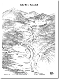
“The watershed, located in the eastern central portion of King County, is nearly 24 miles long, and roughly 10 miles wide. Total acreage of the watershed is approximately 91,400 acres. Mountain crests in the Cascade Range form the eastern boundary of the system, and the Cedar River flows westward through the center.
The Landsburg headworks, where water is diverted into pipelines to the Seattle supply system, is at the westernmost boundary of the watershed. From there the Cedar River continues downstream to Lake Washington, 13 miles to the northwest. Chester Morse Lake (originally Cedar Lake) is the main storage reservoir with original lake surface 1,530 feet above sea level, subsequently raised to elevation 1,560 feet by Masonry Dam.
Most of the watershed is below elevation 1,600 feet and is a deep permeable glacial deposit (moraine). Masonry Dam sits on this deposit. When reservoir storage levels are high, in a single month as much as one third of the reservoirs contents are lost to seepage. Fortunately 90 percent of the seepage eventually returns to the Cedar River above the water supply diversion point. So the moraine serves two important water supply functions. First, it filters the water. Second it acts as a delayed secondary storage reservoir for a large quantity of water that might otherwise spill past the diversion point and be lost to the sea. Over the years the City has learned how to manage this natural storage.”
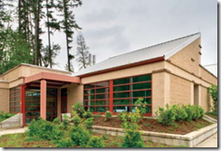
After being drawn from the river, water is treated in a state-of-the-art facility. The LEED  Gold rated operations building, near Renton, houses an analytical laboratory and offices in addition to a control room for the treatment plant.
Water is brought to Mercer Island by pipeline and stored in twin 4 million gallon storage tanks located near the MI Public Library, and is thence distributed through city pipelines to more than 7000 homes and businesses.
Routine water quality testing is performed to meet health regulatory requirements. In addition to SPU testing, the City of Mercer Island conducts testing and produces an annual report on water quality.


